


Latest Version
Version
1.0.1
1.0.1
Update
August 28, 2025
August 28, 2025
Developer
TD CONSTRUCTION INVESTMENT AND TRADING SERVICES
TD CONSTRUCTION INVESTMENT AND TRADING SERVICES
Categories
Tools
Tools
Platforms
Android
Android
Downloads
0
0
License
Free
Free
Package Name
com.sb.gpszoom.mapmeasure
com.sb.gpszoom.mapmeasure
Report
Report a Problem
Report a Problem
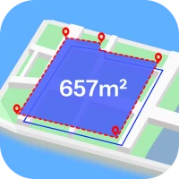
More About GPS Fields Area: Measure Map
GPS Fields Area Measure is a helpful tool for measuring land areas, distances, and map points with GPS technology. Designed for practical use in agriculture, construction, land management, or everyday location tracking, the app offers accurate results and essential features to support your work in the field or planning tasks.
Key features of the GPS area measurement app:
📐 Measure land area on the map
Easily calculate land size and perimeter to support farming, mapping, or land use planning. Area results are precise and suitable for both personal and professional use.
📏 Measure distances along any path
Track distances between multiple locations or across custom paths. This feature supports various needs such as route planning, on-site measurement, or layout checking.
📍 Mark points with GPS coordinates
Save exact location points with latitude and longitude data. It’s ideal for recording landmarks, property corners, or survey points.
🧭 Built-in GPS compass for direction
Use the compass to find orientation and navigate better during outdoor activities. It provides real-time heading based on your device.
💾 Save and organize your measurements
Keep all your area, distance, and marker data in one place. You can label and review your saved measurements anytime you need.
🔄 Convert between measurement units
Switch between metric and imperial units with the built-in converter. Useful when working across regions or sharing data with others.
GPS Fields Area Measure helps you measure with confidence using only your phone. It’s designed for practical needs like land planning, fieldwork, or basic outdoor measuring tasks.
Whether you're measuring for work or personal use, this app supports your needs with clear results and reliable tools. Download now and simplify your field measurements with GPS support.
Rate the App
Add Comment & Review
User Reviews
Based on 0 reviews
No reviews added yet.
Comments will not be approved to be posted if they are SPAM, abusive, off-topic, use profanity, contain a personal attack, or promote hate of any kind.


More »

Popular Apps

Peacock TV: Stream TV & MoviesPeacock TV LLC

Mr.Billion: Idle Rich TycoonIDSIGames

WPS Office-PDF,Word,Sheet,PPTWPS SOFTWARE PTE. LTD.

Ludo King®Gametion

TCG Card Store Simulator 3DBlingames
Statastic Basketball TrackerStatastic Solutions FlexCo

FatsomaFatsoma Android

RealVNC Viewer: Remote DesktopRealVNC Limited

Truth or Dare Game - OweeOwee

Gooka: Unlimited AI ChatALWAYS WITH YOU LLC.
More »
Editor's Choice

Grim Soul: Dark Survival RPGBrickworks Games Ltd

Craft of Survival - Gladiators101XP LIMITED

Last Shelter: SurvivalLong Tech Network Limited

Dawn of Zombies: Survival GameRoyal Ark

Merge Survival : WastelandStickyHands Inc.

AoD Vikings: Valhalla GameRoboBot Studio

Viking Clan: RagnarokKano Games

Vikings: War of ClansPlarium LLC

Asphalt 9: LegendsGameloft SE

Modern Tanks: War Tank GamesXDEVS LTD