
Latest Version
Version
1.0.3
1.0.3
Update
July 23, 2025
July 23, 2025
Developer
AppFlows
AppFlows
Categories
Tools
Tools
Platforms
Android
Android
Downloads
0
0
License
Free
Free
Package Name
com.geokit
com.geokit
Report
Report a Problem
Report a Problem
More About GeoKit: Field Data Collector
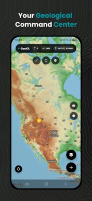
Transform Fieldwork with GeoKit: The Ultimate Geology Mapping & Data Collection App
GeoKit revolutionizes geological fieldwork, offering a complete toolkit for geologists, volcanologists, and mining professionals. Record precise geological features, measure terrain, visualize critical data layers, and export results seamlessly—all offline in remote environments.
🔍 Key Features
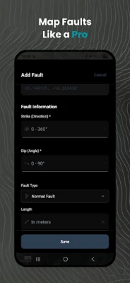
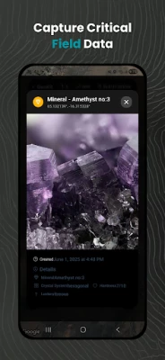
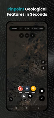
Advanced Geological Markers
Record faults, samples, minerals, outcrops & POIs with custom attributes:
Photo documentation & geotagging
Detailed notes, strike/dip measurements
Mineral composition, rock type classifications
Sample IDs and metadata templates
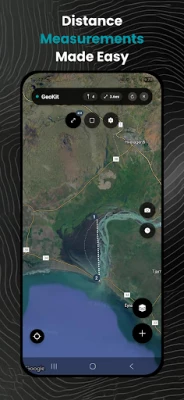
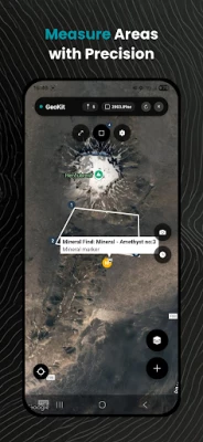
Professional Mapping Tools
Distance & Area Measurement: Accurately plot boundaries, fault lengths, or mineral zones directly on the map.
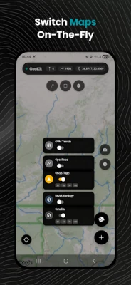
Multi-Layer Maps: Switch between geological, topographic, and satellite layers (including USGS, OpenTopoMap).
Real-Time Altitude Tracking: Instantly view elevation data for any location.
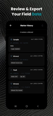
Data Management
Export/Import: Support for GeoJSON, KML, GPX, and CSV formats—integrate with GIS software (QGIS, ArcGIS).
Cloud Sync: Securely backup projects and collaborate across teams.
Specialized Geology Tools
Fault Analysis: Log displacement, orientation, and kinematics.
Sample Cataloging: Track locations, weights, and lithology.
Outcrop Mapping: Document stratigraphy and structural features.
Offline Capabilities
Download maps & work without internet—critical for remote mines, volcanoes, or field sites.
🚀 Why Professionals Choose GeoKit
Precision: Military-grade GPS accuracy for reliable data collection.
Efficiency: Cut fieldwork time by 50% with intuitive forms and one-tap exports.
Safety: Terrain analysis and hazard zone mapping for volcanic/earthquake-prone areas.
Compliance: Meet industry standards (JORC, NI 43-101) with auditable data trails.
🎯 Ideal For
Geologists: Mineral exploration, structural mapping, and field surveys.
Volcanologists: Eruption risk assessment and lava flow tracking.
Mining Engineers: Resource estimation and drill site planning.
Academics: Student field trips and research data collection.
🔍 Key Features
Advanced Geological Markers
Record faults, samples, minerals, outcrops & POIs with custom attributes:
Photo documentation & geotagging
Detailed notes, strike/dip measurements
Mineral composition, rock type classifications
Sample IDs and metadata templates
Professional Mapping Tools
Distance & Area Measurement: Accurately plot boundaries, fault lengths, or mineral zones directly on the map.
Multi-Layer Maps: Switch between geological, topographic, and satellite layers (including USGS, OpenTopoMap).
Real-Time Altitude Tracking: Instantly view elevation data for any location.
Data Management
Export/Import: Support for GeoJSON, KML, GPX, and CSV formats—integrate with GIS software (QGIS, ArcGIS).
Cloud Sync: Securely backup projects and collaborate across teams.
Specialized Geology Tools
Fault Analysis: Log displacement, orientation, and kinematics.
Sample Cataloging: Track locations, weights, and lithology.
Outcrop Mapping: Document stratigraphy and structural features.
Offline Capabilities
Download maps & work without internet—critical for remote mines, volcanoes, or field sites.
🚀 Why Professionals Choose GeoKit
Precision: Military-grade GPS accuracy for reliable data collection.
Efficiency: Cut fieldwork time by 50% with intuitive forms and one-tap exports.
Safety: Terrain analysis and hazard zone mapping for volcanic/earthquake-prone areas.
Compliance: Meet industry standards (JORC, NI 43-101) with auditable data trails.
🎯 Ideal For
Geologists: Mineral exploration, structural mapping, and field surveys.
Volcanologists: Eruption risk assessment and lava flow tracking.
Mining Engineers: Resource estimation and drill site planning.
Academics: Student field trips and research data collection.
Rate the App
Add Comment & Review
User Reviews
Based on 0 reviews
No reviews added yet.
Comments will not be approved to be posted if they are SPAM, abusive, off-topic, use profanity, contain a personal attack, or promote hate of any kind.


More »

Popular Apps

Peacock TV: Stream TV & MoviesPeacock TV LLC

Mr.Billion: Idle Rich TycoonIDSIGames

WPS Office-PDF,Word,Sheet,PPTWPS SOFTWARE PTE. LTD.

Ludo King®Gametion

TCG Card Store Simulator 3DBlingames
Statastic Basketball TrackerStatastic Solutions FlexCo

FatsomaFatsoma Android

3D Chess GameA Trillion Games Ltd
RealVNC Viewer: Remote DesktopRealVNC Limited

Truth or Dare Game - OweeOwee
More »
Editor's Choice

Grim Soul: Dark Survival RPGBrickworks Games Ltd

Craft of Survival - Gladiators101XP LIMITED

Last Shelter: SurvivalLong Tech Network Limited

Dawn of Zombies: Survival GameRoyal Ark

Merge Survival : WastelandStickyHands Inc.

AoD Vikings: Valhalla GameRoboBot Studio

Viking Clan: RagnarokKano Games

Vikings: War of ClansPlarium LLC

Asphalt 9: LegendsGameloft SE

Modern Tanks: War Tank GamesXDEVS LTD