

Latest Version
Version
25.1
25.1
Update
July 09, 2025
July 09, 2025
Developer
Esri
Esri
Categories
Tools
Tools
Platforms
Android
Android
Downloads
0
0
License
Free
Free
Package Name
com.esri.responder
com.esri.responder
Report
Report a Problem
Report a Problem
More About ArcGIS Mission Responder
NOTE: ArcGIS Mission Responder Version 24.4 is compatible with ArcGIS Enterprise 11.5, 11.4, 11.3, 11.2, 11.1, and 11.0 but is not compatible with previous versions of ArcGIS Enterprise.
ArcGIS Mission Responder is the mobile app that enables users in the field to participate in active missions as part of Esri’s ArcGIS Mission product.
ArcGIS Mission is a focused, tactical situational awareness solution that is fully integrated with Esri’s market leading ArcGIS Enterprise product. ArcGIS Mission allows organizations to create, share, and operate in missions using integrated maps, teams, and other mission related materials like photographs, documents, map products, and other information types. ArcGIS Mission is designed to provide organizations with a real-time view of their common operating picture and provides remote, mobile users to situational understanding to be able to answer the question, “What’s going on around me right now?”.
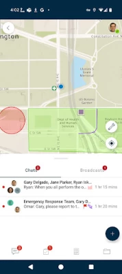
As the mobile component of ArcGIS Mission, Responder is the mobile app that enables operators to maintain communications and collaboration with their teammates as well as others in support of, and participating in, the mission through real time messaging and reporting.
Key Features:
- Secure, protected connection to ArcGIS Enterprise
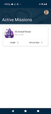
- View and participate in active missions of ArcGIS Enterprise
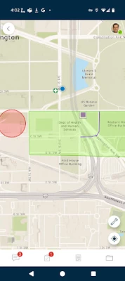
- View, interact and explore mission maps, layers and other resources
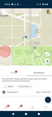
- Send instant messages to other users, teams and all mission participants
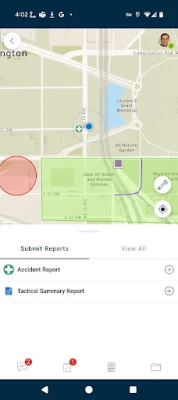
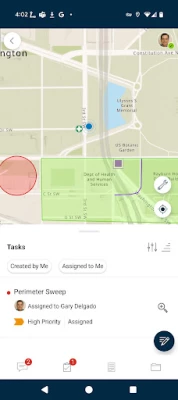
- Receive, view, and respond to user-specific tasks
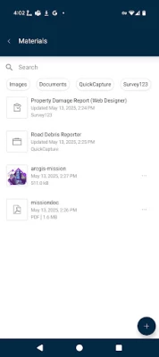
- Use an optimized report form to create and view reports from the field
- Create simple map sketches to communicate and collaborate with other mission participants
- Attach photos and other file-based resources for sharing as GeoMessages
Note: Continued use of GPS running in the background can dramatically decrease battery life.
ArcGIS Mission is a focused, tactical situational awareness solution that is fully integrated with Esri’s market leading ArcGIS Enterprise product. ArcGIS Mission allows organizations to create, share, and operate in missions using integrated maps, teams, and other mission related materials like photographs, documents, map products, and other information types. ArcGIS Mission is designed to provide organizations with a real-time view of their common operating picture and provides remote, mobile users to situational understanding to be able to answer the question, “What’s going on around me right now?”.
As the mobile component of ArcGIS Mission, Responder is the mobile app that enables operators to maintain communications and collaboration with their teammates as well as others in support of, and participating in, the mission through real time messaging and reporting.
Key Features:
- Secure, protected connection to ArcGIS Enterprise
- View and participate in active missions of ArcGIS Enterprise
- View, interact and explore mission maps, layers and other resources
- Send instant messages to other users, teams and all mission participants
- Receive, view, and respond to user-specific tasks
- Use an optimized report form to create and view reports from the field
- Create simple map sketches to communicate and collaborate with other mission participants
- Attach photos and other file-based resources for sharing as GeoMessages
Note: Continued use of GPS running in the background can dramatically decrease battery life.
Rate the App
Add Comment & Review
User Reviews
Based on 0 reviews
No reviews added yet.
Comments will not be approved to be posted if they are SPAM, abusive, off-topic, use profanity, contain a personal attack, or promote hate of any kind.


More »

Popular Apps

Peacock TV: Stream TV & MoviesPeacock TV LLC

WPS Office-PDF,Word,Sheet,PPTWPS SOFTWARE PTE. LTD.

Mr.Billion: Idle Rich TycoonIDSIGames

FatsomaFatsoma Android
Statastic Basketball TrackerStatastic Solutions FlexCo

Ludo King®Gametion

TCG Card Store Simulator 3DBlingames

Truth or Dare Game - OweeOwee

Gooka: Unlimited AI ChatALWAYS WITH YOU LLC.

RealVNC Viewer: Remote DesktopRealVNC Limited
More »
Editor's Choice

Grim Soul: Dark Survival RPGBrickworks Games Ltd

Craft of Survival - Gladiators101XP LIMITED

Last Shelter: SurvivalLong Tech Network Limited
Dawn of Zombies: Survival GameRoyal Ark

Merge Survival : WastelandStickyHands Inc.

AoD Vikings: Valhalla GameRoboBot Studio

Viking Clan: RagnarokKano Games

Vikings: War of ClansPlarium LLC

Asphalt 9: LegendsGameloft SE

Modern Tanks: War Tank GamesXDEVS LTD